
Guidelines for Developing Low-rise into High-rise Affordable Residences to Increase Green Space in the Phase 2 -The Raminthra Urban Renewal of the National Housing Authority
Article Sidebar
Main Article Content
Abstract
As a result of the development and expansion of government infrastructure, the city has expanded into suburban areas. Therefore, there has been the development of housing that is appropriate for the ever-changing urban context. And because it is a city with a higher density of buildings, project development in the form of redevelopment represents the process of developing limited land to restore the original physical structure. and increases living space and usable space. In addition, the development of the area must take into account open space and green space, which must be provided adequately to meet the needs of residents in the area. The National Housing Authority has a policy to allocate housing in the city to make it more stable and orderly. Reduce the problem of urban slums in line with the direction of urban development. Raise the quality of life to develop housing in urban communities. (20-year Housing Development Master Plan 2017-2036, Ministry of Social Development and Human Security) Therefore, the Raminthra City Rehabilitation Project was born, which is one of the main projects according to this development master plan.
This research aims to study and present guidelines for developing the area of the Raminthra Urban Renewal Project-Phase 2, which was originally a residential project with low-rise into high-rise. To add open space and green space to the project in accordance with the project development plan of the National Housing Authority. Including guidelines for developing the area to be more beneficial according to the potential of the land where the project is located. In this research, related theories and requirements were studied, resulting in guidelines for choosing three alternatives, with building height being the determining variable in each alternative. By format 1, it is an 8-story building, which is the most common height in today's mixed-use residential developments. Format 2 and Format 3 The height of the building will be determined according to the National Housing Authority's development master plan, which is 15- stories and 35 stories, respectively. Each model must take into account three factors: (1) Housing standards of the National Housing Authority. (2) Increasing open space. Green area, which is a sustainable green area, and (3) The beneficial use of land and construction worthiness.
From the study of all Model 3 alternatives, it was concluded that Model 2 can be designed to have sustainable green space that is appropriate and sufficient for the residents of the project to increase residential units beyond the development master plan of the project. National Housing Authority, is more cost-effective in terms of construction than Model 3, and is appropriate for the current project location context.
Article Details
References
กนกวลี สุธีธร. (2548). หลังคาเขียว : ทางเลือกเพื่อการจัดการน้ำฝน. วารสารวิชาการคณะสถาปัตยกรรมศาสตร์, 1, 125-137.
กระทรวงการพัฒนาสังคมและความมั่นคงของมนุษย์. (2560). แผนยุทธศาสตร์การพัฒนาที่อยู่อาศัยระยะ 20 ปี พ.ศ. 2560-2579. กระทรวง.
กองฟื้นฟูเมืองและจัดรูปที่ดิน. ฝ่ายฟื้นฟูและพัฒนาเมือง 2. (2564). โครงการฟื้นฟูเมืองรามอินทรา. ฝ่าย.
ชาญวิทย์ ทองสัมฤทธิ์. (2564). พื้นที่สีเขียว. https://www.onep.go.th/พื้นที่สีเขียว/
ธารรวี งามศิริอุดม. (2561). สัณฐานการเปลี่ยนแปลงที่ดินจัดสรรขนาดเล็กในเขตศูนย์กลางทางธุรกิจของกรุงเทพฯ กรณีศึกษา ถนนศาลาแดง แขวงสีลม เขตบางรัก [วิทยานิพนธ์ปริญญามหาบัณฑิต, จุฬาลงกรณ์มหาวิทยาลัย]. Chula ETD. https://digital.car.chula.ac.th/chulaetd/3519
นภสร จินดาพงษ์. (2565). การศึกษาหลักเกณฑ์พื้นที่สีเขียวในรายงานผลกระทบสิ่งแวดล้อม โครงการที่อยู่อาศัยประเภทอาคารชุดพักอาศัยรวม เขตกรุงเทพมหานคร [วิทยานิพนธ์ปริญญามหาบัณฑิต ไม่ได้ตีพิมพ์]. จุฬาลงกรณ์มหาวิทยาลัย.
น้ำทิพย์ พรโชคชัย. (2563). FAR OSR คืออะไร? ส่งผลกับราคาที่ดินด้วยนะ. https://www.feasyonline.com/content/detail/1202/far-osr
พัฒน์ จันทะโชติ. (2557). แนวทางการพัฒนาเคหะชุมชนสำหรับผู้มีรายได้หลายระดับ : กรณีศึกษาโครงการเคหะชุมชนห้วยขวาง [วิทยานิพนธ์ปริญญามหาบัณฑิต, จุฬาลงกรณ์มหาวิทยาลัย]. Chula ETD. http://cuir.car.chula.ac.th/handle/123456789/46646
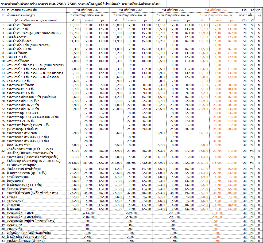
มูลนิธิประเมินค่า-นายหน้าแห่งประเทศไทย. (2566). ราคาประเมินค่าก่อสร้างอาคาร พ.ศ. 2566. https://testarea427blog.files.wordpress.com/2024/02/67-0098.jpg
วิมลสิทธิ์ หรยางกูร และนิลุบล คล่องเวสสะ. (2542). พฤติกรรมนันทนาการกับสภาพการใช้พื้นที่สาธารณะภายในชุมชนอยู่อาศัยของการเคหะแห่งชาติ. คณะสถาปัตยกรรมศาสตร์ จุฬาลงกรณ์มหาวิทยาลัย.
สฤษดิ์ ติยะวงศ์สุวรรณ. (2012, January-June). การพัฒนาที่ดินบราวน์ฟิลด์ - Brownfield Development. วารสารวิชาการคณะสถาปัตยกรรมศาสตร์ สจล., 14(1), 137-147.
สำนักการวางผังและพัฒนาเมือง. (2566). (ร่าง) แผนผังกำหนดการใช้ประโยชน์ที่ดินกรุงเทพมหานคร ฉบับปรับปรุงครั้งที่ 4. สำนัก.
สำนักงานนโยบายและแผนทรัพยากรธรรมชาติและสิ่งแวดล้อม. (2560). แนวทางการจัดทำรายงานการวิเคราะห์ผลกระทบสิ่งแวดล้อมโครงการหรือกิจการด้านอาคาร การจัดสรรที่ดิน และบริการชุมชน. สำนัก.
Aruninta, A. (2016). Green design concepts. In Landscape architectural design and construction technology (pp. 293-294).Chulalongkorn University Press.
Untermann, R. K., & Small, R. (1977). Site planning for cluster housing. Van Nostrand Reinhold. https://books.google.co.th/books?id=RRJUAAAAMAAJ
URA. (2024). About us. https://www.ura.gov.sg/Corporate/About-Us/What-We-Do
