DEVELOPMENT OF CULTURAL TOURISM MAP UNDER MOBILE PHONE
Keywords:
cultural map, Chan Sen Ancient City, cultural tourism, mobile application, Google Maps API GIS Titanium MobileAbstract
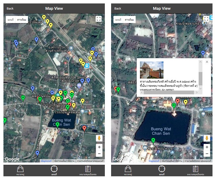
The main objective in this study is to develop the cultural map for tourism at Chan Sen Ancient City via mobile application under android operating system. The results from the survey of the community tourism in terms of latitude and longitude are employed to develop the cultural map using Google Maps APIs as a tool to collect historical data by creating the maker using Titanium Mobile for mobile application. The results from this study demonstrated that the tourists can download the program at Chan Sen Museum which can show where the objects in the museum found in the ancient city. They are very satisfied with the program because it is friendly-user, and they can choose the places to visit and the program will display the map including traveling routes, time, and pictures. In addition, the program is very good for the students to study when they are small tour guides. It can be concluded that the program is not only the navigation map for tourism, but also integrates the local culture that enhances and encourages the communities to preserve the unique culture. Moreover, the application leads to an increase in number of tourists and the community income as well.
References
มณีรัตน์ แก้วศรี. (2560). สำนักงานพัฒนาชุมชนอำเภอตาคลี. [ออนไลน์]. ค้นเมื่อ 10 กุมภาพันธ์ 2561. เข้าถึงจาก http://nakhonsawan.cdd.go.th/wp-content/uploads/sites/24/2017/05/ovc-เมืองทวารวดีศรีจันเสน.pdf
Downloads
Published
Issue
Section
License
บทความที่ได้รับการตีพิมพ์เป็นลิขสิทธิ์ของ สบศ.


